Wahikuli-Honokōwai Watershed Management Plan, NOAA Coral Reef Conservation Division
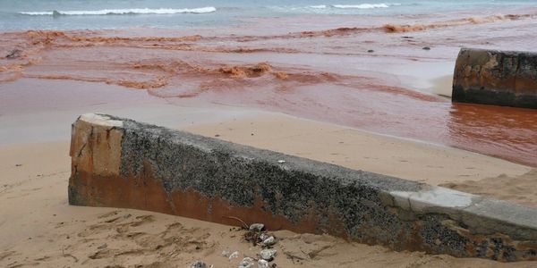
The West Maui region is targeted by Federal, State, and private entities for watershed planning efforts with the goals of reducing stressors to and improving the overall health of coral reefs, nearshore waters, and watersheds. The Watershed Management Plan characterizes Wahikuli and Honokōwai Watersheds and provides a framework for addressing control of non-point source pollution through pollution control strategies, implementation strategies, evaluation and monitoring protocols, and education and outreach approaches. SRGII developed the plan using EPA guidance and it was used as a template for planning in neighboring West Maui watersheds. Implemented recommendations are expected to reduce generation and transport of land-based pollutants, resulting in improved water quality and coral reef ecosystem health.
Management Planning for Maunakea, Office of Maunakea Management
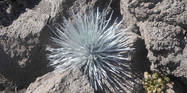
Maunakea, the tallest mountain in the Hawaiian Islands, encompasses a wide variety of ecosystems and hosts the world’s largest ground-based astronomical observing site. SRGII was part of a team that developed the Maunakea Comprehensive Management Plan (CMP) for the UH Management Areas, which analyzed and integrated information on natural and cultural resources, human activity, and resource threats, to develop management strategies to preserve and protect Maunakea’s unique resources. As part of the CMP, SRGII developed a natural resources management plan, a decommissioning plan for Maunakea observatories, and a public access plan for University of Hawai‘i management areas. These plans were approved by the Board of Land and Natural Resources and are used to guide management activities.
‘Ōhi‘apilo Ponds Comprehensive Wetland Management Plan, Department of Hawaiian Home Lands
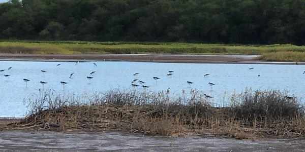
‘Ōhi‘apilo Ponds is part of a larger wetlands complex located on the leeward shore of Moloka‘i that is utilized by native and migratory birds, including endangered species. SRGII developed a Comprehensive Wetland Management Plan (CWMP) to guide habitat management and improvement of deteriorated conditions. Field work included documenting: vegetative species and location, bird populations, predator presence, causes of bird mortality, and hydrologic conditions. The CWMP outlines designs and strategies for wetland maintenance and enhancement, cost estimates for management actions along with priority rankings, permit requirements, and potential funding sources. Recommendations address hydrologic issues, invasive plants, mammalian predators, avian botulism, monitoring strategies, and effects of climate change.
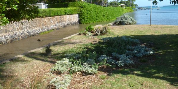
Ecological Assessment of Inoa‘ole Stream with Management Recommendations, Bellows Air Force Station
.JPG/:/cr=t:16.67%25,l:0%25,w:100%25,h:66.67%25/rs=w:600,h:300,cg:true)
SRGII assessed watershed condition with an emphasis on evaluating stream conveyance capacity in the portion of Inoa‘ole Stream located within Bellows AFS. Multi-disciplinary investigations were conducted including: stream hydrology, water quality, fish and avian habitat, soils and topography, channel morphology, land use, and hydraulic analysis. Specific tasks were designed to assess the ecohydrologic characteristics of Inoa‘ole Stream, evaluate channel conveyance, and assess the sediment contribution to the stream and vegetation buildup that could cause upstream flooding. The project provided information to improve water quality in Inoa‘ole Stream by documenting on-base sources and sinks of sediment and pollution. Management recommendations to address watershed impairment issues were outlined.
Watershed Based Plan for Wailupe Watershed, Mālama Maunalua
Wailupe Watershed was prioritized for the development of an EPA Watershed Based Plan (WBP) that described and delineated the locations and land use activities leading to increased run-off during storm events and transport of land based pollutants to Maunalua Bay. Utilizing a strategic watershed planning process and geospatial data analysis, SRGII identified and located solutions designed to reduce land based pollutant loads and attenuate overland flow. Solutions were recommended based on their highly efficient pollutant-reducing systems, ease of maintenance, and successful utilization in Hawaiʻi. The WBP provided a strategic and technical framework for immediate remedial action to reduce land-based pollution threats to Maunalua Bay. Follow-on implementation projects have been funded.
Hawaiian Monk Seal: Public Perception, NOAA Protected Resources Division
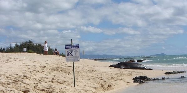
SRGII investigated the knowledge, attitudes, beliefs, and behaviors of targeted groups regarding the endangered Hawaiian monk seal (Monachus schauinslandi). SRGII designed and conducted a state-wide survey to gather information about people’s knowledge and opinions regarding monk seals in the wild. The results of the survey were used in conjunction with a review of existing education and outreach materials, interviews and talk story sessions to develop recommendations for education and outreach. NOAA is using these recommendations to inform messages and methods to more effectively reach critical audience groups and initiate change in their behaviors toward the Hawaiian monk seal
Coconut Rhinoceros Beetle Trap Monitoring and Maintenance, NAVFAC Pacific
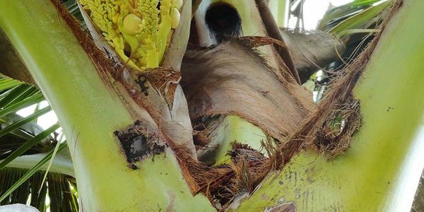
SRGII performed monitoring and control of the coconut rhinoceros beetle (CRB) across Joint Base Pearl Harbor Hickam, Hawai‘i (JBPHHH) parcels on O‘ahu. Weekly maintenance and monitoring was conducted for an average of 700 traps a week. Breeding site surveys sought to identify potential areas of CRB habitat on JBHHH. Reports summarized monitoring and maintenance activities and included CRB catch results and geographic information system (GIS)-rendered maps reflecting the spatial extent of CRB.
Ecosystem Based Management Review of Fishery Ecosystem Plans, WPRFMC

The Western Pacific Regional Fishery Management Council (WPRFMC), one of eight regional Fishery Management Councils nationwide, is responsible for conservation and management of the fisheries in Hawai‘i, American Samoa, Guam, and the Northern Mariana Islands. SRGII reviewed the WPRFMC Fishery Ecosystem Plans (FEP) to assess how well ecosystem based fisheries management (EBFM) principles had been incorporated, and provided recommendations for improving incorporation of EBFM into management processes.
Integrated Natural Resources Management Planning, COMFLEACT Sasebo
The U.S. Navy Command, Fleet Activities Sasebo (COMFLEACT Sasebo) is an overseas installation located on the Western coast of Kyushu Island, in Japan. SRGII developed a comprehensive Integrated Natural Resources Management Plan (INRMP) that provides details on the current status of the abiotic and biotic resources, identifies knowledge gaps, and provides clear management recommendations based on the best available science. Field work was completed to update existing biological inventories. An invasive species management plan was developed and incorporated as an appendix. Education and outreach materials were developed to assist in engaging the local and on‐base community in natural resource issues.
Watershed Based Plan for Hanalei Watersheds, Hanalei Watershed Hui
Hanalei Bay is listed as a Clean Water Act Section 303(d) impaired water body. Ongoing water quality monitoring and assessment efforts identify sediments, nutrients, and microbial pathogens as pollutants of concern in the Hanalei Bay watersheds. SRGII developed a watershed based plan using EPA’s elements of watershed planning. The plan presented a watershed characterization of the four contributing watersheds, identified sources of land-based non-point source pollutants, and provided specific strategies to remediate the land-based pollutants. Recommendations in the plan are targeted for funding from the State Department of Health’s Clean Water Branch Polluted Runoff Control Program.